
Inspections, 3D Models and Manangement services for buildings and constructions.
Manage construction projects more efficiently with aerial imagery and drone data.
Professional construction drone services.
Track, map, search, inspect and manage your workplace projects with UltraBird. Construction drone and aerial data services are the innovative solution for providing sophisticated analysis or providing a visual progress report to stakeholders. DroneBase has worked on thousands of construction sites across the country and has all the insurance needed to do the job safely and compliantly.

Construction monitoring
Aerial photography with drones helps keep projects on track. Make better decisions with drone data and visual project updates.

Orthomosaic Maps
Get highly detailed and geometrically accurate image representations of your workplace.

Maps and 3D Models
Use aerial drone imagery to generate 3D models of your location, stock measurements and more.
3D Models of Buildings & Constructions
Improve coordination with your team and subcontractors using a visual record of site conditions
Utilize a 3D model of your construction for a detailed, comprehensive and measurement accurate view
No need for engineers and workers to be at the site of the construction. View the entire project from home with ease, saving costs and time
Expedite
Construction Projects
Detect plan deviations during Quality Assurance & Quality Control by comparing site reality to pre-construction designs from Procore, Bluebeam, Plangrid, etc.
Track and communicate progress at any stage with a tailor-made Progress Report
Verify work with automated cut/fill analysis and side by side comparisons
Stay Connected to Your
Project from Anywhere
Improve coordination with your team and subcontractors using a visual record of site conditions
Review aerial data alongside ground data with UltraBird’s 360º cameras for a comprehensive view of the project
Increase trust with your clients by sharing an accurate digital reconstruction of your job site
Automatically share DroneDeploy maps in your project management solutions, like Procore or Autodesk BIM 360
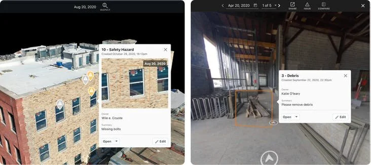
Quality Control & Inspection
By discovering an issue early, you can save up to millions of dollars in repairs, fines, and disputes across all of your projects. UltraBird’s accurate and 3D models of the construction site helps you and your project to perform inspections that are much quicker, safer and cheaper.
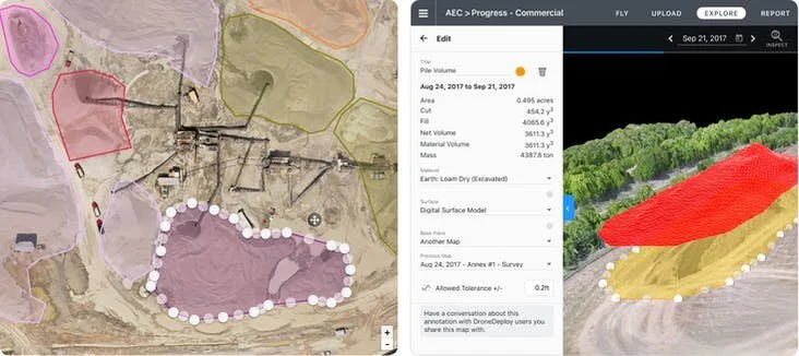
Earthworks &
Stockpile Analysis
UltraBird’s Earthworks capabilities make it faster and easier than ever to accurately measure earthmoving needed to reach finished grade – helping you win bids, keep projects on schedule, and the entire project team updated on progress. Capture and process accurate drone-based elevation data in a matter of hours.
Exterior Assessment
Vertical Flight and the drone inspection workflow allow you to inspect structural elements such as windows and building envelopes from the safety of the ground. If any issues arise, you have visual data time-stamped to help in your claim.


Interior Assessment
Virtually walk through your properties to conduct interior inspections. Create issue tags in each panorama and view a timeline of your 360 videos or photos to assess conditions.
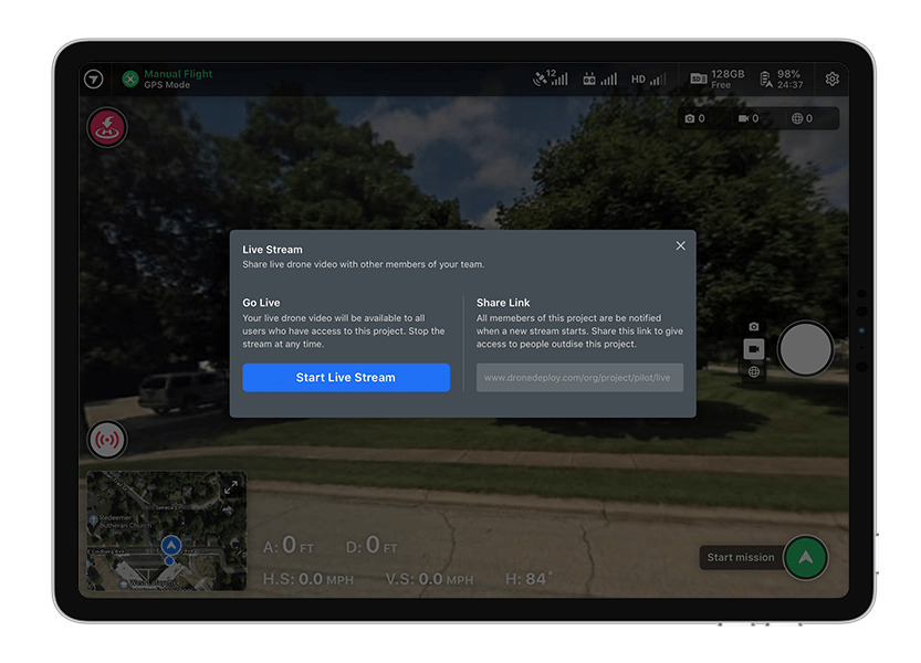
Drone Live Streaming
Have everyone of your team remotely watch the drone inspection, live.
Quickly identify damages, issues, or active hazards
Gives teams immediate context, facilitating transparent collaboration
Improve response times and situational awareness
Any other reasons to use drone imagery in construction sites?

Visual insights
Stay in step with important project milestones and keep them on schedule with the help of our 3D models generated with the help of our drones.

Increased return on investment
Reduce work, delays and additional costs with constant monitoring of your project. Our drones ensure that project objectives are achieved much faster when compared to projects monitored by humans.

Volumetric measurements
Our drones are able to make ultra-accurate measurements to calculate the area, distance and volume of assets in your project, making your employees spend less time on activities that can now be automated.